White River sees fourth highest crest
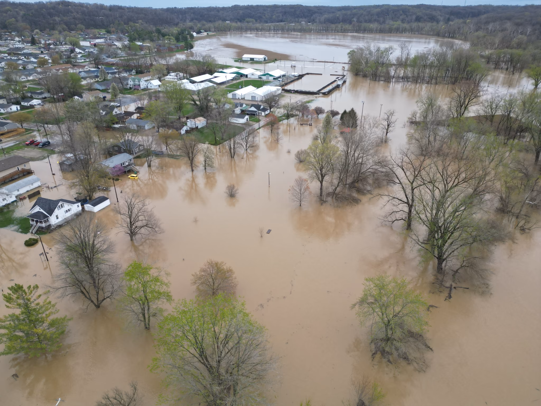
Owen County saw historic flooding in early April following several days of rainy weather, leading to a warning or red travel advisory. A resolution from the Owen County Commissioners is required to enact the highest level of travel advisory.
The crest for the river based on measurements from the National Water Prediction Service as part of the National Oceanic and Atmospheric Administration (NOAA) was the fourth highest crest since at least 1913. The White River in Spencer crested at 24.41 feet on April 7 between midnight and 1 a.m.
The highest historic crest was 28.5 feet on March 26, 1913. The second and third highest crests were at 26.84 feet on June 6, 2008 and 25.08 feet on Jan. 7, 2005, respectively.
The fifth highest historic crest was 23.95 feet on Jan. 1, 1991, making this event the highest crest since the 100-year flood of 2008. Anything over 24 feet is considered a major flood by NOAA.
In preparation for the flooding, the State of Indiana offered skids of 50 pre-filled sandbags for pickup in Bedford, and the Owen County Highway Department left its entrance gate unlocked during April 5 and 6 to allow public access for anyone in need to fill and haul their own sandbags. These were offered without charge.
Throughout the flooding event, Owen County Water Rescue made a total of 11 water rescues, according to Emergency Management Director Jack White.
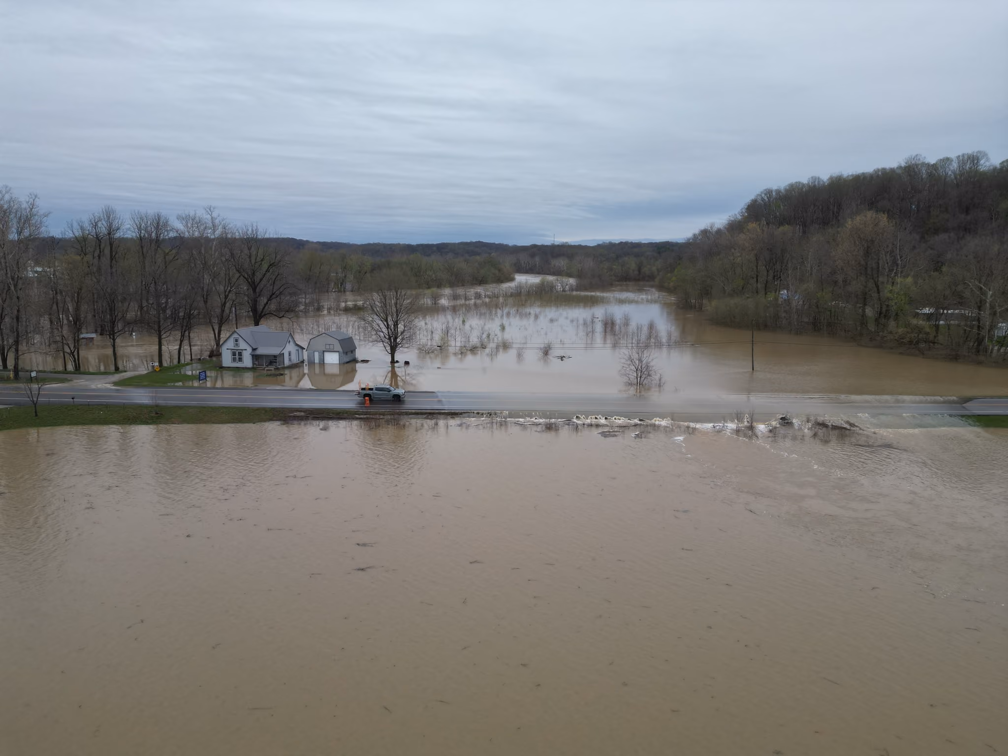
County roadways incurred an estimated $15,302,675 in roadway damage assessed by the Owen County Highway Department (OCHD) as of April 25. The highway department was still assessing the full damage, and OCHD Superintendent Greg Melton said he would not be surprised if that number doubled, as new reports of damage from the event are still being added to the list.
On April 11, Indiana Governor Mike Braun declared a state of emergency for 18 counties, of which Owen County was included.
"Due to flooding, storm, and tornado damage, I am declaring a state of disaster emergency in Bartholomew, Brown, Clark, Crawford, Dearborn, Delaware, Gibson, Hamilton, Harrison, Lake, Madison, Marshall, Martin, Owen, Perry, Posey, Spencer, and Warrick counties. This is effective for 30 days and allows the Indiana Department of Homeland Security to begin providing financial assistance to impacted communities who have eligible expenses under the State Disaster Relief Fund program," Braun said in a press release. "It is my hope that this step enables residents, businesses, and local governments to access needed resources and assistance as they assess and recover from these devastating weather events."
Photos shared on Facebook on April 8 by county commissioner Sam Hobbs shows Braun assessing the damage alongside Hobbs and commissioner Dave Risk. Senator Jim Banks and Senator Todd Young also sent out members of their teams to view the damage in Owen County.
Flood stage for the White River begins at 14 feet as a minor flood. Moderate flooding begins at 20 feet, and major flooding begins at 24 feet.
According to NOAA, when the White River in Spencer measures 14 feet, lowland flooding begins in the Spencer and Gosport areas and Rattlesnake, Fall, McCormick's, Limestone, Big and Bean Blossom Creeks begin to back up, and the Spencer Public Access site to the river begins to flood.
At 15.5 feet, County Line Road in Owen County begins to flood on the north side of the river, Romona Road west of Gosport begins to flood, and flooding of low agricultural land is noticeable.
At 16 feet, the lowest portions of trails one and seven at McCormick's Creek State Park flood.
At 16.3 feet, County Line Road south of Gosport begins to flood.
At 17 feet, a few mobile homes located downstream of Spencer are isolated due to their driveway lanes being flooded. In addition, County Line Road on the north side of the river has one foot of water and begins to flood in a second place.
At 17.2 feet, high water affects the Owen County Fairgrounds parking lot and county roads in the Freedom area.
At 18 feet, flooding begins at the Owen County Fairgrounds and Cooper Commons on the south side of Spencer.
At 19 feet, the road south of the river gage begins to flood and extensive agricultural flooding is in progress.
At 20 feet, Hyden Road, Fifth Avenue and the west side of Cooper Street in Spencer begin to flood.
At 21 feet, the Prospect Park area of Spencer and East Street begin to flood.
At 22 feet, some evacuations may begin in Prospect Park and the western outskirts of Spencer. Flood waters affect the southern part of Freedom, and the rural area north of Freedom extensively floods.
At 22.5 feet, the east side of Cooper Street on the south side of Spencer begins to flood.
At 23 feet, flooding affects all homes in the Prospect Park area in western Spencer, and evacuations are necessary. The fairgrounds parking lot and arena flood.
At 24 feet, a major flood is in progress, and as many as 150 people may be forced to evacuate from the western outskirts of Spencer.
At 24.3 feet, Prospect Park on the west side of Spencer extensively floods. Streets within Spencer that are partially flooded on the south side of town include East Cooper Street, East Clay Street, South West Street, South Montgomery Street, South Main Street, South Washington Street, South Harrison Street and South East Street. Sandbagging is necessary on the south side of Spencer.
At 24.6 feet, the road located on the east side of Owen Valley Middle and High Schools begins to flood.